-
-

-
-
-
-
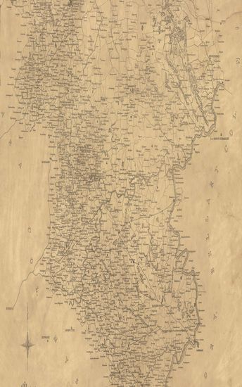
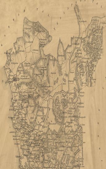
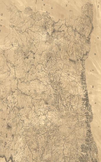
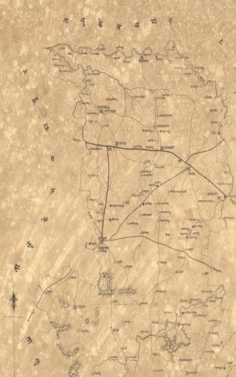
- Map of the Dharwar Collectorate. 1874
- Year: 1875
-
-
-
-
-
-
-
-
-

-
-
-
-
-
-
- Map of the Coompta Talooka (Kumta taluka) of North Kanara 1880.
- Year: 1880
- Subject: Topographic Map
- Publisher: Poona (Pune) Government Photozincographic Office 1880
- Language: English
- Place of Publication: Poona (Pune)
-
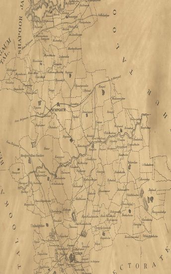
- Map of the Madeh (Magha) Taluka of the Sholapur (Solapur) Zilla.
- Year: 1872
- Subject: Topographic Map
- Publisher: Poona (Pune) Government Photozincographic Office 1872
- Language: English
- Place of Publication: Poona (Pune)
-
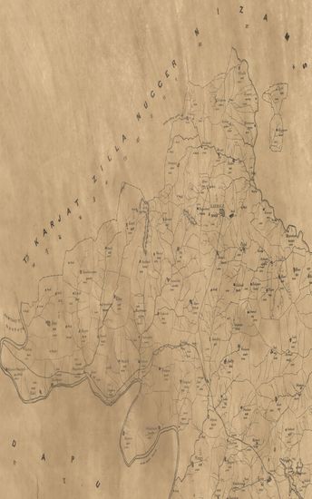
- Map of the Chikodee taluka of the Belgaum collectorate.
- Year: 1878
- Subject: Topographic Map
- Publisher: Poona (Pune) Government Photozincographic Office 1878
- Language: English
- Place of Publication: Poona (Pune)
-
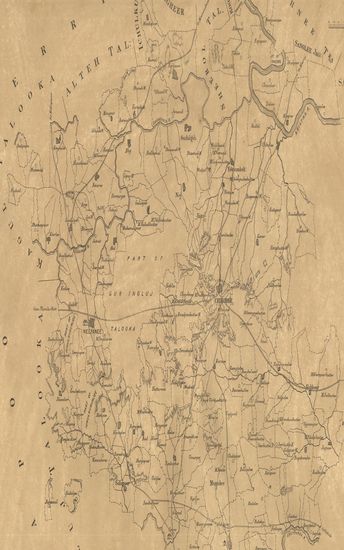
- Map of the Sumpgaon taluka of the Belgaum district.
- Year: 1878
- Subject: Topographic Map
- Publisher: Poona (Pune) Government Photozincographic Office 1878
- Language: English
- Place of Publication: Poona (Pune)
-
- Map of the Karmale Taluka of the Sholapur Zilla.
- Year: 1873
- Subject: Topographic Map
- Publisher: Poona (Pune) Government Photozincographic Office 1873
- Language: English
- Place of Publication: Poona (Pune)
-
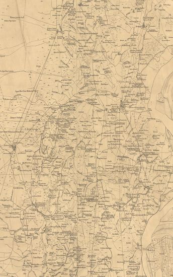
- Map of the Dharwar Collectorate. 1874
- Year: 1875
- Subject: Topographic Map
- Publisher: Poona (Pune) Government Photozincographic Office 1875
- Language: English
- Place of Publication: Poona (Pune)
-
- Map of the Penn Taluka of the Colaba Zilla.
- Subject: Topographic Map
- Publisher: Poona (Pune) Government Photozincographic Office
- Language: English
- Place of Publication: Poona (Pune)
-
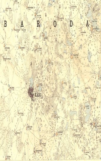
- Guzerat, Sheet No.78 : Parts of the Ahmedabad District, of the Kari and Pattan Talukas of the Gaikwar's Territory, of Kattywar, and of Mahi Kanta States. 1875-76
- Year: 1877
- Subject: Topographic Map
- Publisher: Dehradun G.T.S. Office 1877
- Language: English
- Place of Publication: Dehradun
-
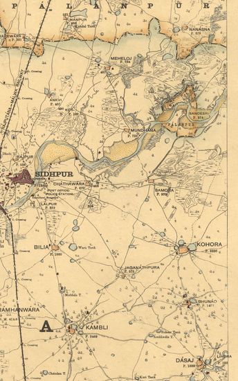
- Guzerat, Sheet No.76 : Parts of the Gaikwar's Territoty, and of the Palanpur and Thara Sates. 1881-82
- Year: 1882
- Subject: Physical Map
- Publisher: Dehradun Office of the trignometric branch. Survey of India 1882
- Language: English
- Place of Publication: Dehradun
-
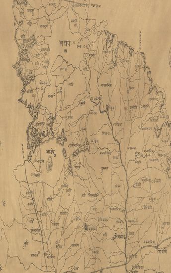
- Map of the Dindori Taluka of the Nasik (Nashik) Zilla. - नकाशा दिंडोरी तालुका जिल्हा नाशिक .
- Year: 1878
- Subject: Topographic Map
- Publisher: Poona (Pune) Government Photozincographic Office 1878
- Language: English
- Place of Publication: Poona (Pune)
-
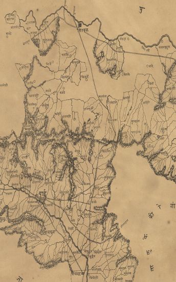
- नकाशा तालुके खटाव जिल्हा सातारा . - Map of the Khatav Taluka Satara District .
- Year: 1875
- Subject: Topographic Map
- Publisher: Poona (Pune) Government Photozincographic Office 1875
- Language: English
- Place of Publication: Poona (Pune)
-
- नकाशा तालुके वाई जिल्हा सातारा . - Map of the Wai Taluka Satara District .
- Year: 1875
- Subject: Topographic Map
- Publisher: Poona (Pune) Government Photozincographic Office 1875
- Language: English
- Place of Publication: Poona (Pune)
-
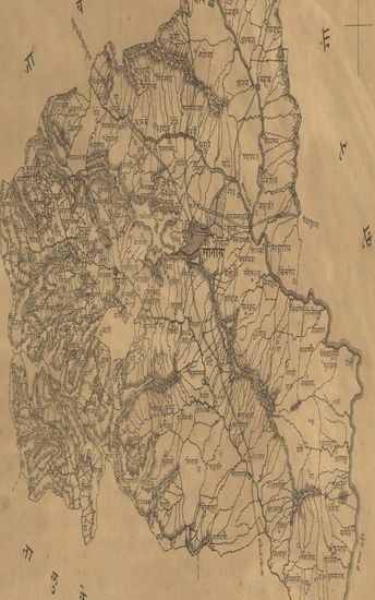
- नकाशा तालुके सातारा जिल्हा सातारा . - Map of the Satara Taluka Satara District.
- Year: 1875
- Subject: Topographic Map
- Publisher: Poona (Pune) Government Photozincographic Office 1875
- Language: English
- Place of Publication: Poona (Pune)
-
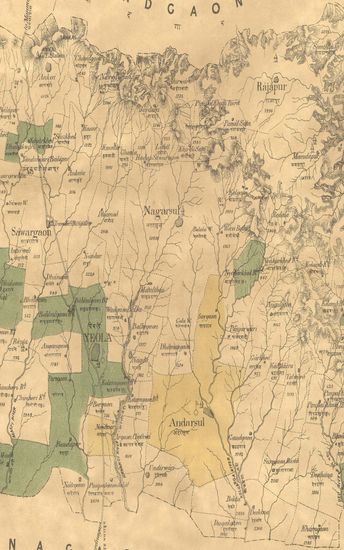
- Map of the Yeola Taluka of the Nasik (Nashik) Zilla.
- Year: 1876
- Subject: Topographic Map
- Publisher: Poona (Pune) Government Photozincographic Office 1876
- Language: English
- Place of Publication: Poona (Pune)
-
- Map of the Khed Taluka of the Poona (Pune) Zilla.
- Year: 1875
- Subject: Topographic Map
- Publisher: Poona (Pune) Government Photozincographic Office 1875
- Language: English
- Place of Publication: Poona (Pune)
-
- Map of the Gokak taluka, Belgaum collectorate
- Year: 1877
- Subject: Topographic Map
- Publisher: Poona (Pune) Government Photozincographic Office 1877
- Language: English
- Place of Publication: Poona (Pune)
-
- Guzerat, Sheet 78 Section 2 : Parts of the viramgam taluka of the Ahmedabad collectorate and of the Wanod and Dasara States (Season 1875-76)
- Year: 1877
- Subject: Topographic Map
- Publisher: Dehradun G.T.S Office 1877
- Language: English
- Place of Publication: Dehradun
-
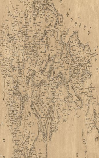
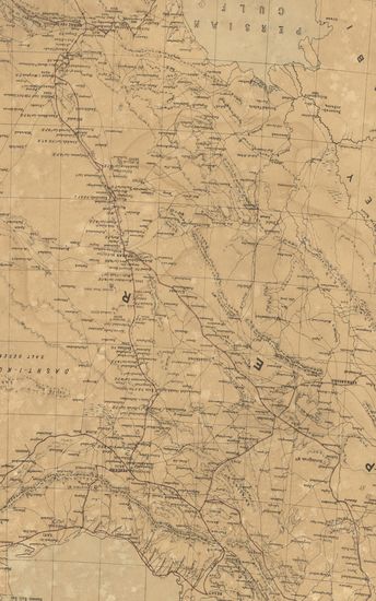
- Turkestan with adjoining portions of the British, Russian and Native Territories. (Sheet No.1)
- Year: 1873
- Publisher: Dehradun Surveyor General's Office 1873
- Language: English
- Place of Publication: Dehradun
-
- नकाशा तालुके खामगांव जिल्हा वराड . - Map of the Khamgaon Taluka District Varad .
- Year: 1874
- Subject: Topographic Map
- Publisher: Poona (Pune) Government Photozincographic Office 1874
- Language: English
- Place of Publication: Poona (Pune)
-
- Districts Sehwan, & Nowshera Surveyed in 1861-62-63. Sind Revenue Survey (Sheet No.37)
- Year: 1870
- Subject: Cadastral Map
- Publisher: Calcutta Surveyor General's Office 1870
- Language: English
- Place of Publication: Calcutta