-
-
-
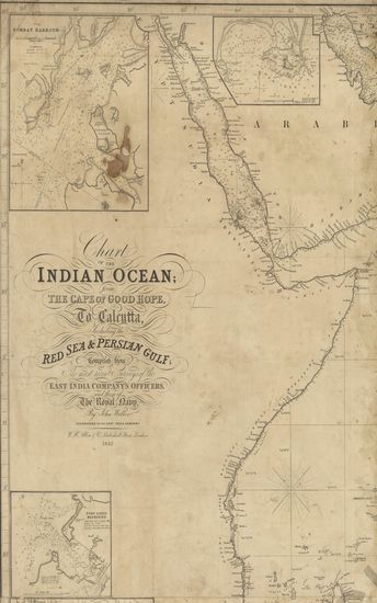
- Chart of the Indian Ocean from the Cape of Good Hope, t ...
- Year: 1842
- Author: Walker, John
-
-
-
-
-
-
-
-
-
-
-
-
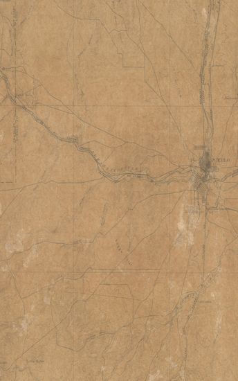
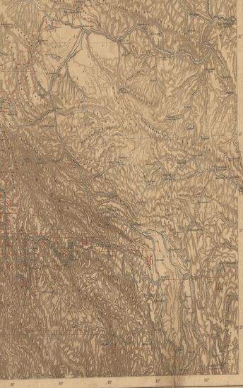
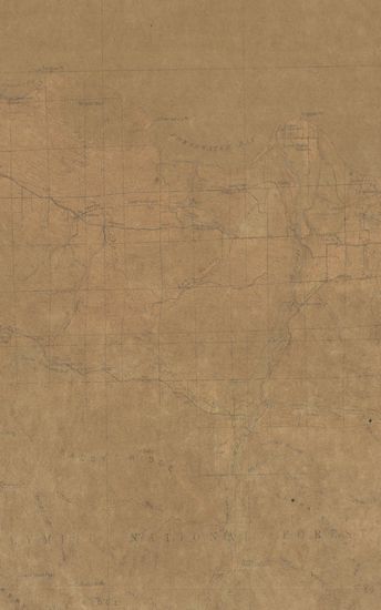
- Colorado Pueblo Sheet Surveyed in 1894
- Year: 1897
-
- Washington Samish Lake Quadrangle Surveyed in 1917 in C ...
- Year: 1918
- Author: Marshall, R.B.
-
-
-
-
-
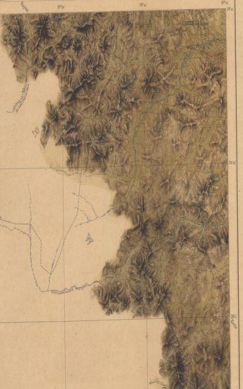
- Nord-ost Tibet. IIl. Teil (Gebiet Kiang-tschu-Yach-tschu) Lager XXXIV bis LV Expedition Tibet 1903 To 1905. (Blatt 35)
- Year: 1905
- Subject: Topographic Map
- Publisher: Berlin E.S. Mittler & Sons 1905
- Language: English
- Place of Publication: Berlin
-
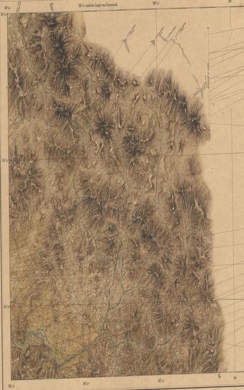
- Nord-ost Tibet. IIl. Teil (Gebiet Kiang-tschu-Yach-tschu) Lager XXXIV bis LV Expedition Tibet 1903 To 1905. (Blatt 23)
- Year: 1905
- Subject: Topographic Map
- Publisher: Berlin E.S. Mittler & Sons 1905
- Language: English
- Place of Publication: Berlin
-
- Chart of the Indian Ocean from the Cape of Good Hope, to Calcutta, Including the Red Sea & Persian Gulf
- Year: 1842
- Author: Walker, John
- Publisher: London W.H.Allen & Co. 1842
- Language: English
- Place of Publication: London
-
- Tarwaree (Tarwadi) Surveyed in 1868-69 corrected upto 1st June 1870 Bombay Revenue Survey. (Sheet No.LXXV).
- Year: 1871
- Publisher: Poona (Pune) Photozincographical Government Office 1871
- Language: English
- Place of Publication: Poona (Pune)
-
- Georgia-Alabama Rome Quadrangle Surveyed in 1895-96 & 1898
- Year: 1904
- Publisher: Washington US Geographical Survey 1904
- Language: English
- Place of Publication: Washington
-
- Gujarat : Parts of the Khandesh and Nasik Collectorates, of the Dang States of the Khandesh Agency, of the Gaikwar's Territory, and of the Bansda State. 1877-82. Trigonometrical Survey Of India
- Year: 1885
- Subject: Topographic Map
- Publisher: Dehradun Office of the Trigonometrical Branch : Survey Of India 1885
- Language: English
- Place of Publication: Dehradun
-
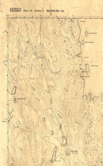
- Guzerat, Sheet 80 Section 10 : Parts of the Viramgam, Dholka, Sanand Talukas of the Ahmedabad Collectorate with detached portion of the Lagtar State (Season 1873-74)
- Subject: Topographic Map
- Publisher: Scales Differ [4:0.0000631313131313] Four Inches to One Statue Mile (Chain = 1 Mile)
- Language: English
- Place of Publication: Scales Differ
-
- Nord-ost Tibet. IIl. Teil (Gebiet Kiang-tschu-Yach-tschu) Lager XXXIV bis LV Expedition Tibet 1903 To 1905. (Blatt 33)
- Year: 1905
- Subject: Topographic Map
- Publisher: Berlin E.S. Mittler & Sons 1905
- Language: English
- Place of Publication: Berlin
-
- Nord-ost-tibet Schara-Kuto (kuku-nor)-oberlauf des Huangho-sung-pan-ting Expedition China Tibet 1903 To 1905.
- Year: 1905
- Subject: Topographic Map
- Publisher: Berlin E.S. Mittler & Sons 1905
- Language: English
- Place of Publication: Berlin
-
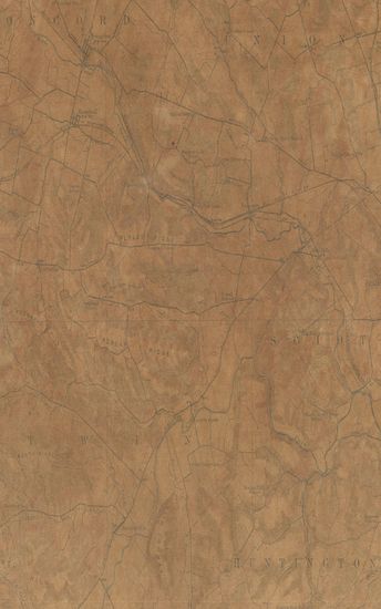
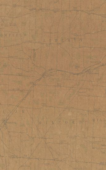
- Ohio (Ross County) Roxabell Quadrangle surveyed in1911-12 in cooperation with the sate of Ohio
- Year: 1914
- Subject: Topographic Map
- Publisher: Washington US Geological Survey 1914
- Language: English
- Place of Publication: Washington
-
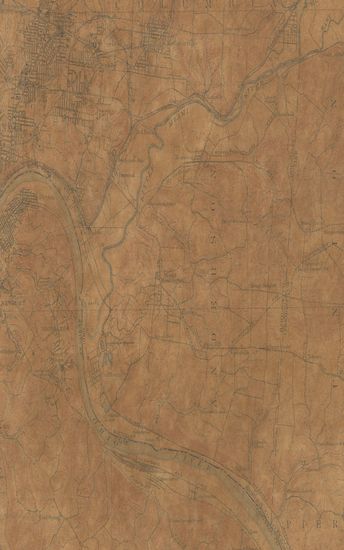
- Ohio-Kentucky East Cincinnati Quadrangle surveyed in 1898 culture revised in 1912
- Year: 1914
- Subject: Topographic Map
- Publisher: Washington US Geological Survey 1914
- Language: English
- Place of Publication: Washington
-
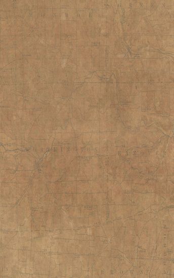
- Ohio Perryville quadrangle surveyed in1912 in cooperation with the state of ohio
- Year: 1915
- Subject: Topographic Map
- Publisher: Washington US Geological Survey 1915
- Language: English
- Place of Publication: Washington
-
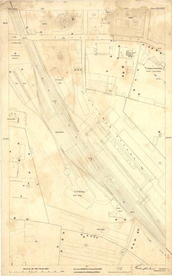
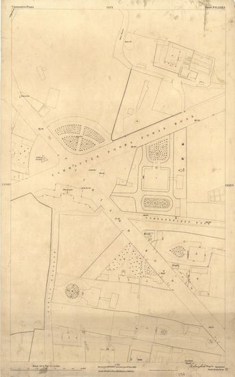
- Cammattee Poora (Kamatipura) Surveyed in 1870-71 corrected upto 1st june 1871 Bombay Revenue Survey. (Sheet No.LXXXV).
- Year: 1872
- Publisher: Poona (Pune) Photozincographical Government Office 1872
- Language: English
- Place of Publication: Poona (Pune)
-
- Ohio Fredericktown Quadrangle Surveyed in 1912 in Cooperation With the State of Ohio
- Year: 1915
- Publisher: Washington US Geological Survey 1915
- Language: English
- Place of Publication: Washington
-
- Colorado Pueblo Sheet Surveyed in 1894
- Year: 1897
- Subject: Topographic Map
- Publisher: Washington US Geological Survey 1897
- Language: English
- Place of Publication: Washington
-
- Washington Samish Lake Quadrangle Surveyed in 1917 in Cooperation with the War Department
- Year: 1918
- Author: Marshall, R.B.
- Subject: Topographic Map
- Publisher: Washington US Geological Survey 1918
- Language: English
- Place of Publication: Washington
-
- Washington ( Clallam county) Port Crescent Quadrangle Surveyed in 1917-1918 in Cooperation with the War Department & the State of Washington
- Year: 1919
- Subject: Topographic Map
- Publisher: Washington US Geological Survey 1919
- Language: English
- Place of Publication: Washington
-
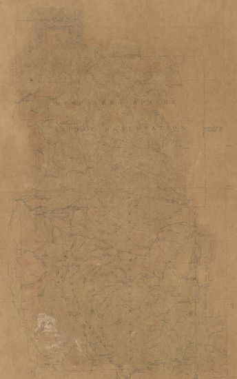
- New Mexico (Grant county) Van Zandt Quadrangle Surveyed in 1917-18 in Cooperation with the War Department
- Year: 1919
- Subject: Topographic Map
- Publisher: Washington US Geological Survey 1919
- Language: English
- Place of Publication: Washington
-
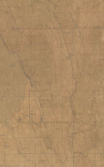
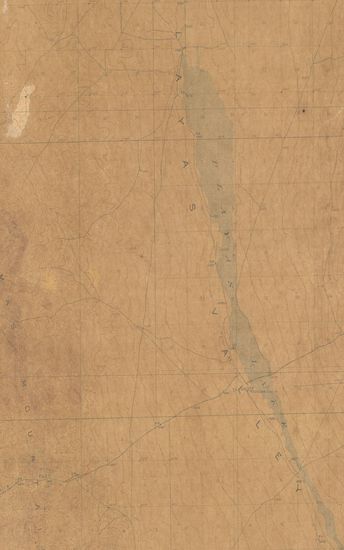
- New Mexico Alamo National Forest ( exclusive of Guadalupe mtns) Surveyed in 1909-1911
- Year: 1914
- Subject: Topographic Map
- Publisher: Washington US Geological Survey 1914
- Language: English
- Place of Publication: Washington
-
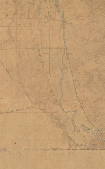
- New Mexico Texas Conutillo Quadrangle Surveyed in 1917 in Cooperation with the War Department
- Year: 1919
- Subject: Topographic Map
- Publisher: Washington US Geological Survey 1919
- Language: English
- Place of Publication: Washington