

-

-

-

- Ceylon N.W.part approaches to Jafnapatam
- Year: 1878
-

- Jamkhandi water works; general plan
- Year: 1877
-

- Map of Gogo Taluka, Ahmedabad district
- Year: 1878
-

-

- The Times Daily, 17 April 1928
- Year: 1928
-
-

-

-

-

-

-

-

-

- Trigonometrical survey of Pauban Pass
- Year: 1839
-

-

-

-

- Map of the Pardi taluka, Surat district
- Year: 1876
-
- Plan of the Cantonments and Civil station Mount Aboo in Rajpootana, 1870
- Year: 1871
- Subject: Topographic Map
- Publisher: Surveyor General's Office
- Language: English
- Place of Publication: Calcutta
-
- Plan of Rohree, sukkur and Fort Bukkur, surveyed in February and March 1856
- Year: 1870
- Subject: Topographic Map
- Publisher: Surveyor General's
- Language: English
- Place of Publication: Calcutta
-
- Ceylon N.W.part approaches to Jafnapatam
- Year: 1878
- Subject: Topographic Map
- Publisher: Marine Surveyor Department
- Language: English
- Place of Publication: Calcutta
-
- Jamkhandi water works; general plan
- Year: 1877
- Subject: Topographic Map
- Publisher: Government Photozinco office
- Language: English
- Place of Publication: Poona
-
- Map of Gogo Taluka, Ahmedabad district
- Year: 1878
- Subject: Topographic Map
- Publisher: Government Office
- Language: English
- Place of Publication: Poona (Pune)
-
- Rangoon river; a trigonometrical survey of by Capt D. Rojs
- Year: 1825
- Subject: Topographic Map
- Publisher: Marine Surveyor General
- Language: English
-
- The Times Daily, 17 April 1928
- Year: 1928
- Publisher: The Times
- Language: English
- Place of Publication: London
-
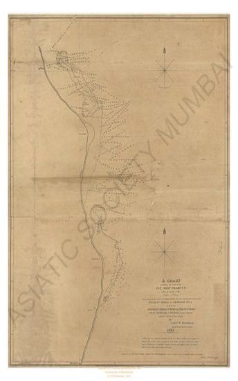
- Coast of Coromandel from the Northern extremity of the Pulicat shoal to Armegon Hill as also the Aremegon shoal & reef off point. Pondy with the anchorage or harbour formed between Armegon shoal & the shore with a chart exhibiting the track of the H.C. ship Nercus while in search of the London Bank by Capt W. Max filed 1821.
- Year: 1822
- Subject: Topographic Map
- Publisher: James Horsburgh
- Language: English
-
- Map of the Ahmedabad district, province Gujarat compiled from the village maps of the Gujarat Revenue suevey ; part II. the five talukas Prantij, Viramgam, Bannad, Daskroi, and Dholka.
- Year: 1878
- Subject: Topographic Map
- Publisher: Government Office
- Language: English
- Place of Publication: Poona (Pune)
-
- Turkestan with the adjoining portions of the British and Russina and Native territories, Sheet No.1
- Year: 1867
- Subject: Topographic Map
- Publisher: Office of the Great Trigonometrical survey of India
- Language: English
- Place of Publication: Dehra Doon (Dehradun)
-
- Turkestan and the countries between the British and the Russian dominions in Asia. 5th ed. Sheet No.4.
- Year: 1881
- Subject: Topographic Map
- Publisher: Survey of India Offices
- Language: English
- Place of Publication: Dehradun
-
- Turkestan and the countries between the British and the Russian dominions in Asia. 5th ed. Sheet No.1.
- Year: 1881
- Subject: Topographic Map
- Publisher: Survey of India Offices
- Language: English
- Place of Publication: Dehradun
-
- Plan of Aden on the coast of Yemen a province of Arabia Felix
- Year: 1866
- Subject: Topographic Map
- Publisher: Chief Engineer's office
- Language: English
- Place of Publication: Bombay
-
- Trigonometrical survey of the Arracan river, 1832
- Year: 1834
- Subject: Topographic Map
- Publisher: James Horsburgh
- Language: English
-
- Trigonometrical survey of Coast of Tinnevelly, 1842
- Year: 1846
- Subject: Topographic Map
- Publisher: John Walker
- Language: English
-
- Trigonometrical survey of Pauban Pass
- Year: 1839
- Subject: Topographic Map
- Publisher: John Walker
- Language: English
-
- Map of the Ahmedabad district, province Gujarat compiled from the village maps of the Gujarat Revenue surved ; part II Dhandhuka & Gogo Talukas.
- Year: 1878
- Subject: Topographic Map
- Publisher: Government Office
- Language: English
- Place of Publication: Poona (Pune)
-
- Map of the Surat collectorate, Gujarat province compiled from the village maps of the Gujarat Revenue Surve A. D. 1871
- Year: 1871
- Subject: Topographic Map
- Publisher: Government Office
- Language: English
- Place of Publication: Poona (Pune)
-
- Map of Panch Mahal district, province Gujarat compiled from the village maps of the Gujarat Revenue survey
- Year: 1878
- Subject: Topographic Map
- Publisher: Government Office
- Language: English
- Place of Publication: Poona (Pune)
-
- Map of the Pardi taluka, Surat district
- Year: 1876
- Subject: Topographic Map
- Publisher: Government Office
- Language: English
- Place of Publication: Poona (Pune)